Reading a Field Map Before a Land-Use Conversation
Reading a field map before a land-use conversation helps you separate visible features from assumptions and prepare clear questions about boundaries, access and use.
Which line on a field map marks the edge you want to discuss, and which route can someone actually use to reach it? Reading a field map before a land-use conversation helps you distinguish what the page depicts from what still needs explanation. A short routine can turn lines, colours and labels into focused questions without treating the map as proof of ownership or current activity.
You can use the routine in one quiet session or spread it across a few days. The aim is to arrive able to point to a place, describe what the map appears to show and identify what remains uncertain.
Read the map first
Start by identifying what kind of map you have. A farm sketch, estate plan, council land-use map and online aerial image may show different information. Look for a title, legend, north arrow, scale bar, date, source and notes about the symbols. Record anything missing rather than guessing.
A legend explains the map’s colours and patterns. A scale bar relates drawn distance to the ground, while a north arrow shows orientation. These features help with interpretation, but do not establish a legal boundary or show whether a track is open to the public. In an aerial image, a hedge, ditch or shadow can also be difficult to distinguish.
Keep the map clean during this first pass. In your notes, separate printed information from your own observations: “labelled pasture” is not the same as “appears grassy in the image”. Keep the map’s date and source beside your notes; both affect what it can tell you.
Use three clear passes
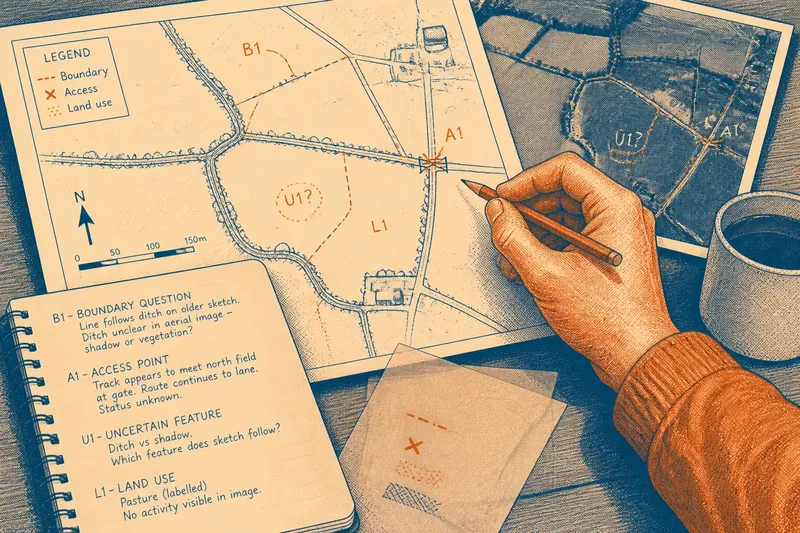
Work through the page in three passes: understand it, mark relevant places, then check your wording for assumptions. Use a pencil or transparent overlay to preserve the original, and a notebook for details that would clutter the map. Give each mark a short label, such as B1 for a boundary question or A1 for an access point, and use the same label in your notes.
- Understand: identify the map type, date, legend and orientation. If key information is missing, note the gap and ask about it rather than filling it in.
- Mark: use separate, simple symbols for boundaries, access points and visible land uses. If a mark would be hard to explain aloud, choose a clearer symbol or describe the place in your notes.
- Check: review every mark for assumptions and turn uncertainty into a neutral question. If the wording makes a claim the map cannot support, rewrite it as an observation or question.
Choose a marking method you can explain without having to decode a complicated key.
Describe boundary features
Trace the edges relevant to the conversation, such as a hedge, fence, wall, ditch, stream, track or change in field pattern. Describe each as a visible feature rather than declaring it the boundary. A line on a map may be approximate, historical or intended for a different purpose.
Mark places where the apparent edge changes direction, meets a lane or passes a building. If two maps disagree, keep both versions and note the difference; do not draw a compromise line. When ownership or a disputed boundary matters, use the map to frame questions and seek appropriately qualified advice if needed.
Imagine you have an older farm sketch and a newer aerial image. The sketch shows a line beside a drainage ditch, but the ditch is hard to distinguish from a shadow in the image. Mark that spot as uncertain, then ask which feature the sketch follows and whether the image is clear enough to interpret. The expected result is a more focused discussion about that stretch, not a boundary decision based on the images alone.
Mark routes and access
Note how a person, vehicle or piece of equipment might reach the area. Mark visible entrances, gates, bridges, tracks, farmyards and connections to public roads. A mapped route does not explain who may use it, whether it is passable now or whether access is shared.
Describe what the map shows without assigning a right or restriction. “Track appears to meet the north field at the gate” gives others a location to discuss; “public access” makes a stronger claim the map may not support. If the route’s status matters, ask which document or local knowledge could clarify it.
Pay particular attention to where a route crosses a boundary or joins another track. Note where the map becomes unclear, rather than recording only the apparent destination.
Record visible land uses
Make a separate pass for the activity or cover that appears to occupy each place. Depending on the map, you may be able to distinguish pasture, cropped fields, woodland, scrub, buildings, yards, ponds or watercourses. Record these as visible or labelled uses, not as a complete account of what happens there.
Land use changes with the season, and a map may show an earlier moment. Bare ground in an image might be between crops, recently worked or awaiting another use. A broad woodland category may hide varied vegetation. Note the map date and ask whether its depiction remains current.
Use plain labels rather than coding every shade of green separately. If an area is hard to read, mark it with a question mark and explain the uncertainty in your notes.
Questions about field maps?
How can I tell whether a map is current?
Look for a date, revision note or image-capture information, then compare it with the features you want to discuss. If the date is absent or unclear, ask when the map was prepared and whether the area has changed since then.
Can a field map confirm ownership?
Not necessarily: maps serve different purposes and may not establish title or a legal boundary. If ownership or a disputed edge matters, ask which authoritative records or professional advice are appropriate.
What if two maps disagree?
Keep the maps distinct and mark where their details diverge. Ask what each map was made to show and which source is appropriate for the question at hand.
How much should I mark before a meeting?
Mark only the places relevant to the conversation: the edges, routes and visible uses in question. A few clearly labelled uncertainties are easier to discuss than a page crowded with interpretations.
Check each question
Before the conversation, review every mark and decide whether it records an observation or an assumption. Replace “unused land” with “no activity visible on this map”, or “access blocked” with “the map does not show a route beyond this point”. These descriptions leave room for information the map cannot show.
- If a line follows a visible hedge, ask which feature the line is intended to represent; if no feature is clear, ask what source could clarify the location.
- If a track meets a gate, ask who uses the entrance and whether its status is documented; if the map cannot show that, note the question for someone with relevant local knowledge.
- If a land-use label matches what is visible, ask whether it remains current; if the image is dated or unclear, avoid presenting the label as a current description.
- If two maps show different edges, ask what each was made to show; if neither resolves the issue, keep both readings separate and seek a more suitable source.
- If a route disappears from the map, ask whether it continues on the ground; if the page gives no answer, record the point where the route becomes unclear.
- If a mark combines a boundary, access and land-use issue, split it into separate questions; if the details are already clear, keep the single mark and explain it in your notes.
Bring the map and notes in a form others can read. If you annotated a copy, retain an unmarked version too. Explain your symbols at the outset and invite corrections; someone with local knowledge may be able to identify an assumption you have missed.
Reading a field map before a land-use conversation is most useful when it directs attention to specific places without pretending the page supplies every answer. For each open question, note what was clarified and which source or person could address what remains. That gives the next conversation a precise starting point.